Hampton Roads Transit Vision Plan


Hampton Roads Transit Vision Plan
(use scroll bar on right side of this window to read description)
LOCATION: Hampton Roads region of southeastern Virginia
CLIENT: Virginia Department of Rail and Public Transportation
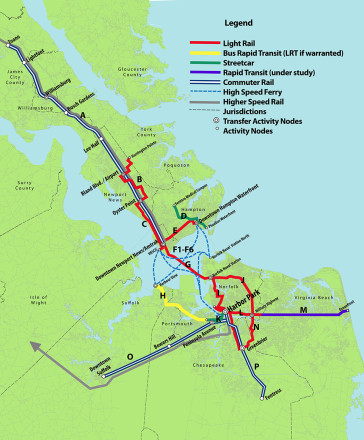
Hampton Roads is one of world’s largest natural harbors, where the historic James and Elizabeth Rivers and several smaller tributaries empty into Virginia’s Chesapeake Bay. This southeastern region of the state is home to nearly 2 million people and has a diverse and stable economy, stemming from shipping and a massive military presence. Hampton Roads faces a major challenge maintaining and creating adequate infrastructure. While the harbor and tributaries remain significant transportation corridors, they present obstacles to land-based commerce and travel. Future development and livability of the area is thwarted by the constraints of aging highway bridges, railroad bridges and tunnels which link the population areas and criss-cross the water bodies. Instead of widening tunnels and roads, and continuing to do piecemeal improvements to the existing infrastructure, the state and region selected a planning team to develop a long-term transit vision for this whole region.
Ed Hamm, as an associate principal at RHI, evaluated the existing regional rail, roadway and transit plans, and worked with the eleven local jurisdictions to select corridors and modes of travel for a comprehensive rail, ferry, and bus transit system. Primary to this complex task was the need to assess the character of each proposed corridor and investigate the potential for new development at each transit node. Designated activity nodes and transfer locations offered opportunities to achieve increased densities and improved neighborhood livability. There was also the opportunity to link the entire system into a central station area to give heightened visibility and functionality to the new transit vision. Both streets and historic rail lines were closely studied for use. Ed led the team through an analysis of the existing community plans and zoning for each recommended corridor and mode of travel. Express bus, enhanced bus, and commuter rail corridors were identified. He made detailed zoning recommendations for each possible transit node, outlining development opportunities. This effort required extensive public outreach and communication with the eleven affected jurisdictions for over 100 miles of light rail, streetcar, ferry and bus rapid transit corridors. RHI assisted AECOM in evaluating the financial feasibility, ridership and capital cost estimates. Thirty six rail and bus corridors were identified and designed into a regional network including an interconnected harbor ferry system. The vision for the transit system was accepted by all eleven jurisdictions and incorporated into their local comprehensive plans. The Transit Vision Plan gives the Hampton Roads area a strategy to achieve greater resiliency over the next decades.